Over the past year of the pandemic, I’ve been spending most of my working days at a desk in the front bay window of our rented home in a four-family house here in Upper Falls. Many cars pass by, a few trucks, and occasionally the MBTA 59 bus.
A century ago, the silence would have been broken most frequently not by cars speeding by, but by the sound of a streetcar running along Elliot St.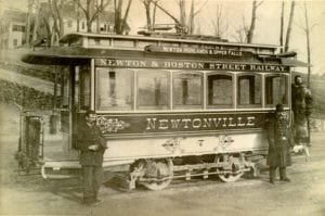
I have a few historic maps of Newton tucked away, and last December I started looking for another, one that would also appeal to my inner railroad nerd: a map of where Newton’s old streetcar lines ran.
The old tax maps of Auburndale and Lower Falls that hang at City Hall outside the elections office clearly show the trolley line that went to Norumbega Park. I’d also seen photos of an old trolley in front of the Stone Estate (now the Stone Institute) on Elliot St. in Upper Falls. Despite these hints, I could find little else in the way of comprehensive, specific maps or history of the trolleys’ locations.
Understanding the history of the streetcars, trolleys, and other railways is important in understanding how Newton grew. Newton’s first large spurt of growth began in the late 1800s as streetcar and trolley lines began to spread across the region. These lines strongly influenced the timing and type of development in our City, and knowing where they ran can provide some insight into what created some of the walkable neighborhood development that we enjoy and appreciate now.
 For all of its impact, the streetcar era was not all that long. The lines (and associated development) began in roughly the 1860s or 70s, hit a fever pitch in around 1910 or so, and then really started to ramp down with the advent of (and replacement by) buses in the 1920s. And that’s a useful thing to remember – the streetcars and trolleys we are talking about here were not uniformly like the higher capacity green line that we think of today. Their capacity and level of comfort were probably more analogous to modern buses.
So, where to go to try to find where the lines ran?
I did a little digging on my own and found several reasonably good sources for figuring out where the tracks used to go – particularly the city’s own historic tax maps from the 1870s through the 1910s (when the lines begin to disappear). Councilor Bill Humphrey and his dad, Thomas, were a very helpful resource. Thomas is a rail historian and has a hand-drawn map that includes many of the lines. I also spoke with Doug Greenfield at the City’s GIS department. Doug had recently done a map of the City’s historic watercourses and was interested in the work I was doing.
The last and most productive resource was Alice Ingerson. She found several period maps that showed most of the lines – some in schematic form, and some areas in detail. Moreover, some of her maps showed how the systems connected up.
I drew from everything I could find to create the this map (click here and it’ll open in Google Maps) of historic streetcar and trolley lines for the City. (I also included some of the heavy passenger and freight lines as these also impacted the structure of our City, and their legacy is quite apparent). Some of these tail off at the borders as I don’t have a great resource for areas beyond, but the picture this paints of the growth of our City is pretty interesting.

Much of the homebuilding between 1900-1920 – when a lot of Newton’s development happened – was concentrated around these lines, enabling the establishment of a new middle class in the City. Developers of that era built the houses and neighborhoods that we recognize as historic now, and they did so largely because of the freedom of movement that the trolleys and streetcars provided. 
Of course, the lines also went through some of the older neighborhoods as well, like Upper Falls. However, these residents were less likely to use the street cars, both because work (at the mill, Gamewell, and other local industry) was a short walk away, and also because streetcar fare was – if not an extravagance – a luxury to be reserved for weekend trips with the family.
Nor were the trolleys entirely reliable. Sometime in the 1970’s, the Jackson Homestead put out a publication “Pre-1855 Newton Houses Remaining in 1972,” and we have been lucky enough to have somehow acquired the volume that covers Newton Upper Falls. The fourth page includes a statement that, “(i)n 1920 a trolley car was snowbound at Pettee and High Streets in February where it stayed until April, cutting off the Needham line for about eight weeks.”
By the way, want to look for a few “ghosts” from the system?
- Trader Joe’s in West Newton? Used to be a car barn for the Washington Street line.
- The odd intersection at High, Elliot, and Oak Streets in Upper Falls? An artifact of the track alignment.
- Same with the alignment of the streets at West Newton Square.
- Exit 125 (West Newton, the old Exit 16) off of the westbound lanes of the MassPike is at least partially on the site of what had been a Boston and Albany rail yard.
- The apartment buildings at 570 Auburn St (and back) are on the site of the storage yard for the trolley line that served Norumbega Park.
- Likewise, there was an engine shed behind the Lutheran Church in Newton Centre in the triangle of land formed by Centre and Cypress Streets and bordered to the south by what is now the D line.
It’s a fascinating detective story, and a lesson that the place that we know now has been shaped by events that happened well before us. And that the things we do now will hopefully provide the means to thrive for those who come after us.
For now, however, I’d love to see if we can do more to flesh out this map of the trolley, streetcar, and light rail lines that served the region in the past. You’ll easily be able to tell the points on my map where “beyond here be dragons.” Please let me know if you have any information or old maps that will allow us to extend this.
Likewise, please send any pictures you have of the streetcar lines in their heyday. I’d love to tag them into the map (if I can figure out how).
EDITED TO ADD: Alex Blumenstiel in the comments had asked about an abandoned trolley line in Waban. I was unfamiliar, but Alice Ingerson came through again! In truth – the line was proposed, but never built. The line would have connected to the Washington St line in the west and connect to the Circuit Railway in the center of Waban. It would have run along the same right-of-way as the aqueduct, in the space in the middle of Waban Ave. The whole Newton Terraces (i.e. Southwest Waban) map is fun to see as well. Speculative development is in no way new to our fair City.


Fascinating subject, Chris. For an analogous historical journey, check out Sam Bass Warner’s “Streetcar Suburbs, The Process of Growth In Boston 1870-1990.” https://www.amazon.com/Streetcar-Suburbs-Process-Growth-1870-1900/dp/0674842111
I recall my father telling me that from his hometown in Bridgeport, CT, you could travel up to RI and MA by taking the streetcars in each town to the town boundary, there to pick up the next next town’s service!
A building recently demolished on the site of what is now Cradles to Crayons was also, I think, owned by the street railway company.
You’ll also find trolley poles around Newton and surrounding towns. I think the large pole in the Highlands may be a trolley pole. There are also a series of them in front of Trader Joe’s, and one on Winchester Street that must have been relocated.
Great stuff Chris!
I love that there seems to be a little detour on the Upper Falls route to take it by my house. I’m guessing it was for an Echo Bridge stop.
Thanks, Jerry. And yes, that detour is interesting – there may have been an Echo Bridge stop, but from what I can find the detour up Chestnut was there as that grade is more gradual and manageable than trying to run trolleys up (and down) Elliot St hill.
Just dug this out of Makers of the Mold, A History of Newton Upper Falls.
Arriving in the late summer of 1892, the railway was ready for the park’s opening in the spring of 1893. It was ready, also, to carry a record number of 5000 persons each pleasant Sunday to the beautiful grounds, the amusements and above all, the glorious seven-arched Echo Bridge which was attractive by day but enchanting when floodlit at night.
Sounds like this was one happening place in 1893 thanks to the new streetcars.
Another interesting bit – the first streetcars in Newton were horse drawn. There was a plan in place for a whole network of horse drawn street cars across the city …. and then electricity arrived.
Chris, Great job! Thank you! (I had thought there was also a trolly line on the aqueduct greenway along Waban Ave. Was I wrong about this?)
Here’s a bit of personal history. When we bought our circa 1820 house in Upper Falls we were more than a little concerned about a lally column in the basement that seemed to be propping up a main support beam of the house.
When we had the formal house inspection I asked the inspector about that and he laughed. He said “that’s what you see. Let me show you what I see”.
He opened up a crawlspace and pointed out an ancient tree stump that was supporting another beam. He said “here’s my favorite” and showed us a piece of railroad track supporting another beam. He said “every 40 or 50 years something started sagging and they took whatever they had and propped it up.”
So it’s possible that our house was having a bit of sagging trouble around the time they pulled up those streetcar rails in Upper Falls.
Related to what Paul’s father told him, UniversalHub had an interesting post about taking commuter rail long distances. It included this lovely vignette:
https://www.universalhub.com/2021/imagine-being-able-take-commuter-rail-here
@Alex – Thanks! No trolley on Waban Ave that I found, but there is a great historic map somewhere of Waban south of Beacon St and west of Chestnut as the land is being developed. I’ll try to find and post a link.
@Adam – you’re right, and I forgot to note the trolley poles. With your reference to Winchester Street, you also reminded me that at least one of the maps that I got from Alice suggests there was another line that went south from Newton Centre into Dedham. Unfortunately, I have not been able to get a confirmation of the route and have left it off so far.
@Meredith Warshaw – sort of reminds me of driving from Maine to Florida entirely on Route 1.
As my mother in law would have wryly said about it “you must be fond of novelties”
Great stuff! In research for my Backside of America blog, I learned that the house at 86 High Street in NUF is a former waiting room for a streetcar line. https://www.google.com/maps/place/86+High+St,+Newton+Upper+Falls,+MA+02464/@42.3151694,-71.2238121,3a,75y,230.42h,90t/data=!3m7!1e1!3m5!1stmBlOcSvAf432f72PxSPmA!2e0!6shttps:%2F%2Fstreetviewpixels-pa.googleapis.com%2Fv1%2Fthumbnail%3Fpanoid%3DtmBlOcSvAf432f72PxSPmA%26cb_client%3Dsearch.gws-prod.gps%26w%3D86%26h%3D86%26yaw%3D230.42235%26pitch%3D0%26thumbfov%3D100!7i16384!8i8192!4m5!3m4!1s0x89e3823b3de23ec3:0xfff1c81a2224cdb7!8m2!3d42.3150724!4d-71.2239627
I heard that 168 Homer was once a station on the trolley line. Anyone have information on this?
This is great stuff, Chris! To follow up on the Waban Avenue electric railway, which was proposed but never built, I’ve added a Google drive link below to the map. Perhaps an authorized Village 14 contributor can post the actual image?
These maps illustrate one thing to bear in mind when looking at the historic atlases and other historic plans:
sometimes they show things that were intended or proposed but never actually built, including platted subdivisions!
Trying again with the Google drive link in the body of this message:
https://drive.google.com/file/d/1U15moAAMl1bBK7UaI9_J65VfIMMWNhJn/view?usp=sharing
On streetcars connecting regions, not just neighborhoods,
I’ll always remember this from the novel, Ragtime:
“The explosion in streetcar lines in America is best illustrated by novelist E.L. Doctorow, who captured their popularity in Ragtime, his famous novel of historical fiction set at the turn of the twentieth century. In the book, one of his characters travels from New York City to Boston, simply by riding the length of each streetcar line, from town to town, all the way up the northeast coast.”
from: https://www.governing.com/archive/suburban-streetcar-desire.html
@Dave Brigham – Those two houses in your photo on High St (the waiting room, and the one next door) were once part of our Spring St property. Sometime after we moved into this house 12 years ago we discovered that the water meter for our house was in the basement of our neighbor’s house – the one on the left in your photo
Alice Ingerson- That map is a terrific find!
“Newton Terraces” isn’t as unique a name as “Waban”, but we probably wouldn’t need to spell it out so often.
Thanks Alice! Just added the map to the main post to keep everything together.
I was just telling my family about Trader Joe’s being an old trolley garage, so what a coincidence that this post is here. Super interesting stuff.
If you’re interested in trolleys, there’s a really fun trolley museum in Maine. You get a ride on an old trolley and they have tons of old trolleys you can look at. Plus the staff there knows everything about trolleys!
@Jerry — too funny!
Also, I meant to cite Makers of the Mold for how I found out about the old trolley waiting room. That book is fantastic!
Chris – I actually have a little guidebook called “Everywhere in Boston and How to Get There”. Published in 1943, it contains a list of Boston-area streets, by town (including Newton) and which trolley, bus, or subway to take to get there. For example, to get to Hull Street in Newtonville, I would take the 114. The 114 was a bus route in 1943, running from Watertown Square to Needham Heights – the forerunner to the modern 59 bus. (There is also an appendix of major landmarks or points of interest, like cemeteries, hospitals, public offices, parks & beaches, and museums.)
Jerry, do you still get estimated meter readings???
Interesting stuff. Thanks Chris!
One of my favorite databases is the Massachusetts Cultural Resource Information System (https://mhc-macris.net/). It’s not particularly easy to use, but there’s a ton of stuff buried in there (including a small write-up on my house and neighborhood, which is fodder for another post).
But in a scanned PDF about a beautiful house at 472 Crafts Street is this:
“The first electric railway charter in Massachusetts was held by the Newton Street Railway Company, who, n 1886, purchased the 18-year old horse-drawn street railway which connected West Newton’s train station with the large American Waltham Watch Company in Waltham by way of Crafts Street. Electrified in 1889, it was extended to Newtonville and Newton Corner.
“As Olaf Ohlson, who lived here in 1895, was a Superintendent at the American Waltham Watch Company, building his house on the streetcar line made his job an easy commute.”
I’ve never seen a map that shows the street line from W. Newton, down Waltham Street to the Watch factory, but I have seen maps and images showing the Newtonville line into Waltham.
Excellent article. The first picture showing The Stone Estate/Institute was in fact built and owned for many decades by the Pettee family and was called Sunnyside. He donated it to create the Stone Institute. I believe he did this in response the the Catholic Church building a large basilica/church directly across from his mansion. He apparently owned the land all the way to the Charles River, and the church obstructed his view. He also was an Episcopalian.
That’s a great resource Chuck. Thanks for the tip.
I just looked up the streetcar waiting room building at 86 High St that Dave Brigham mentioned above. A few other details I learned was that other times it was both an apothecary and a pool hall. I also learned that a water main was first laid on High St in 1894, a time when that property was owned by the same folks who owned my house on the street behind.
Since a water line didn’t come to our Spring St until 2014, the previous owner just had them run the water line through his High St house and on into his other house out back on Spring St.
BTW – Chris started this great post with the line …
A century ago, the silence would have been broken most frequently not by cars speeding by, but by the sound of a streetcar running along Elliot St.
From what I’ve heard, Chris actually did hear a streetcar at his home on Elliot St yesterday
Indeed – someone in a grey hatchback drove by and I could distinctly hear the sound of a trolley going around a corner…. :)
Just made one more edit to the map, adding the Newton Lower Falls “Ping Pong Line” – so named as it ran for decades (1870’s-1957) as either a one-car interurban or a passenger car and a switch engine down the line from Riverside (the old stop on the mainline, not the one we know now) down over to the lumber yard in Wellesley (now a CVS and housing development). There’s more about the line here: http://urbanvista-boston.blogspot.com/2014/10/newton-lower-falls-branch-route-of-ping.html Two quick items – the bridge over the Charles was restored in 2014 through Rep Kay Kahn’s efforts to get funding from the Commonwealth. Second, note Tom Humphrey’s name prominently cited as a source in the article. The man is a true resource for all things rail history in Massachusetts.
Fascinating stuff, Chris. Thank you!
Thank you, Chris, for this wonderful bit of history. I was delighted to find it as I was researching electric trolleys for a proposal I’m writing re: converting the Chaffin Estate in Newton Corner into the “Museum of Transportation and Society”. I hope to win the support of the Newton Corner Neighborhood Association and present this idea as part of a larger economic development plan to our alderman next month. I believe Newton Corner is an ideal place for such a museum because the history of the village is intertwined with the evolution of transportation modalities. The village was established to meet transportation needs of early farmers, grew with the advent of the railroad and trolleys and was eviscerated by the construction of the freeway.
The motto of the proposed museum is; “How We Move Is How We Live” and the intent is to educate the public about the importance of transportation to economic and social development . I’ve designed a number of interactive exhibits focused on different transportation modes to entertain and inform both children and adults. Although my background is in sociology, business and economic development, and I worked as an economist in the Executive Office of Economic Affairs in the first Dukakis administration, I’m totally self-educated with regard to transportation systems. I’m aware of my deficits in this area and would like to contact the experts you mention in this piece, especially Alice Ingersol and Thomas Humphrey, to benefit from their expertise. I’m sure conversations with them would be very helpful.
I would like to ask you for your advice and support as well, and would be more than happy to send you a copy of my work (but please don’t publish this email as a comment – at least not yet.) Do feel free to contact me at: [email protected]. Thank you, in advance, for your consideration.
Best regards,
Robin Boger