 This is an updated version of this post to reflect the recently updated route for this trail. The new slightly longer 3 mile route now goes over Route 9 to Eliot station and then overlaps with a bit of the much longer six mile aqueduct trail before heading up through Hemlock Gorge and over Echo Bridge.
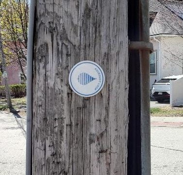
Little round signs recently appeared in my Upper Falls neighborhood.
One day recently I followed the signs and they led me on a very pleasant, roughly 2 1/2 three mile, walking loop that passed through seven different Upper Falls park lands – Hemlock Gorge, Braceland Park, Charles River Walk, Upper Falls Greenway, Frank Barney Conservation Area, Martin Poetry Path, and the Sudbury Aqueduct.
The route is half on wooded paths through parks and half on back streets.
The route is sign-posted going in both directions. Two easy places to find the loop are on Echo Bridge or on the Upper Falls Greenway where it crosses at Oak St. Just keep your eyes open and look for these signs every time you come near any decision point (fork, street crossing, etc) and they will lead you around the whole loop.
Here are the details of the route ….
* Over Echo Bridge and take the first path to the left down the hill
* Follow the path to the street, turn left on Central Ave/Eliot St
* Before you get to the traffic light turn right on River Ave
* Left on Keefe St
* Follow into Braceland Park
* Head to the right, down the hill to the gate at the bottom left corner of the park
* Through the gate, follow the River Walk path to the old rail road bridge
* Walk up the stairs to the Upper Falls Greenway.
* Follow Greenway path to Chandler Place (at the end of white Boston ballet building on right and turn left
* Turn right on Columbia Ave and go up the hill to Elliot St
* Cross Eliot at the pedestrian crossing and then turn right
* Go to the entrance on the left to the Frank Barney Conservation area (across from fire station).
* At the other end of Frank Barney continue a very short way down Circuit Ave to the entrance to the Martin Poetry Path on left
* Follow the Martin Poetry Path up the hill and back down again.
* Left on Circuit Ave
* Right on Route 9
* Two blocks down turn right to get on the pedestrian overpass to Eliot station
* In the station, stay on the same side of the tracks and go through the gate on the left to Meredith Rd
* First right on Canterberry Rd
* Follow Canterberry Rd until you see the sign pointing right down a short path to the aqueduct
* Turn left on the Sudbury Aqueduct
* At the Route 9 exit ramp, turn right
* Go two blocks and turn left under Route 9 on Ellis St (at Quinobequin Rd)
* Go up Ellis St to the stairs on the left that lead up to Echo Bridge
 This is an updated version of this post to reflect the recently updated route for this trail. The new slightly longer 3 mile route now goes over Route 9 to Eliot station and then overlaps with a bit of the much longer six mile aqueduct trail before heading up through Hemlock Gorge and over Echo Bridge.
p.s. Weather predictions look good for a walk on Sunday afternoon.
This is great news. I cannot jointhe group but definately will go and walk this loop in the near future!
Hey Jerry – this is a great idea! I’ll have to walk it during the week also as I am not in town this Sunday. Also – looking forward to stopping in to Little Lukes; the menu looks great!
Another wonderful opportunity to wander and wonder with community.Thanks for organizing!
Great! For far too long, I’ve neglected the various walking paths around town, so I’m trying to make up for lost time. Might just make it to the Sunday perambulation.
Great. Love to see you there
Join us for the walk on Sunday at 1 PM, starting at Chestnut & Oak St
Wow!
35 people turned up today to walk the Upper Falls Loop. It was a perfect day for it and it was a wonderfully friendly and sociable crowd of walkers. We’ll have to do another different walk soon. Here’s a photo.
Wound up having a social/musical commitment I simply couldn’t turn down. Reckon I’ll take the walk on my own. Glad everyone had a good romp.
Love this idea! Would it be possible to post a MAP of the route? Street names, \ right/left turns etc. are not my strong suit.
Maybe, if I can find a a tool to do that easily.
In the meantime though you should just be able to follow the signs rather than the written directions.
@Margaret Thomas – Does this map work for you? I just tried to cobble something together using Google Maps
Dear Jerry,
Fantastic! It’s perfectly clear now. This is just what I needed, and I am excited to try it out tomorrow. Thank you so much. I hope I run into you sometime on the Loop so I can thank you in person.
Best wishes
MT
My pleasure!
I added this walk to Alltrails: https://www.alltrails.com/explore/map/map-july-24-2023-32fcc8c?u=i&sh=r3sgvz
That’s great. Thanks Joshua!