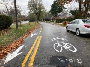
Carriage Road Westbound near Cedar Street
If you walk, bike, run, or drive on Commonwealth Avenue’s Carriage Road, you have probably noticed some changes of late. Different kinds of lines – faint white, dashed yellow, and even solid double yellow- have appeared before, after, and across some intersections without signage or explanation. In other sections, such as between Mt. Alvernia and Bullough Park, the road has signs, striping, and even sharrows. What gives?
All these are the result of the legalization of two-way bicycle traffic on the miles of Carriage Road, from Mt. Alvernia to the east side of Lyons Field, approved on March 17 2022 by the Public Safety and Transportation Committee after a series of public comment sessions. The city’s slow rollout of the eastbound bike path, a result of rainy days and a staffing shortage, has raised more than a few eyebrows.
Step one was removing, late this summer, the cobblestones placed by multiple intersections decades ago. So many cobbles were getting loose or coming out that people were stumbling over them, particularly in the winter. Whatever the State’s intention in installing them, the cobbles had to go. Their removal over the length of the Carriage Road has allowed thermoplast-painting of proper crosswalks to assist safe crossing of Commonwealth Avenue. This is a big step for the safety of pedestrians, runners, seniors, children getting to and from school, and people with disabilities.
Next, an array of signs- red, green, arrows that point in one or another direction, “Bike Lane,” “Except Bicycles,” and smaller six-sided “STOP” signs- are being installed. A dedicated eastbound bike lane, placed alongside the berm, is being thermoplast-painted before and after each intersection with dashed yellow lines becoming solid double yellow lines to delineate the approach to each intersection. In this section of lane, arrows and sharrows point east. Attention-getting dashed green rectangles with dashed white outer lines define that lane through the intersection.
These road markings and new signs should alert northbound and southbound drivers crossing the Carriage Road to be mindful of westbound and eastbound bicyclists, runners and pedestrians. They encourage drivers to obey the posted STOP signs. On another note, parking has long been prohibited along the berm side of the Carriage Road, a restriction that includes landscapers and contractors. Expect a few “NO PARKING BIKE LANE” signs to appear soon along the berm as a reminder.
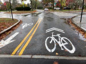
Sharrow Pointing West and Bike Lane Pointing East
In the center section of the Carriage Road, bicycle sharrows pointing west have been thermoplast-painted at intervals to indicate that motor vehicle drivers are sharing this road with cyclists. Here, on the Carriage Road, it is expected that cyclists will travel slowly to safely coexist with those on foot and in cars (speedier cyclists will continue to ride in the dedicated bike lanes on Commonwealth Avenue.)
When this project was proposed over a decade ago, it was agreed that the eastbound bike lane would not compromise the tranquility of the Carriage Road. I believe DPW has so far done an excellent job in preserving this quality while still improving safety for Carriage Road users. In places where the signs, arrows, lane markers, and sharrows are now posted, drivers are already driving more carefully.
Refitting the Carriage Road for two-way bike traffic remains a work in progress. Since the roadwork began in the east at Mt. Alvernia Road and has been making its way west, you might live where dotted and double yellow lines exist by themselves without signage – hence, the confusion. Nonetheless, the City is committed to getting work crews out there when it can in coming weeks to complete the painting and signage.
As a final note, we ask for your patience as the work proceeds. Though it is still too early to break out the champagne, it’s great to know that more improvements and greater safety are in the pipeline for the Carriage Road, and that Frederick Law Olmstead’s dream of a linear park is coming to pass.
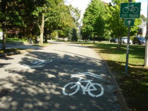
Carriage Road as linear park.

Jane, thank you for this wonderful update and your continued tireless advocacy for making the Carriage Road a Newton gem! It’s been exciting to see the paint and signs go in at last.
Here is the project website with information from the two-way biking public meetings and the final plans: https://www.newtonma.gov/government/planning/transportation-planning/projects/commonwealth-avenue-carriageway-2-way-bike-travel
Thank you Jane!
Agreed that the carriage road is an amazing and unique gift to have in Newton. It is used by families, runners and slower cyclists all the time.
This effort to paint the bike lanes on the east bound side of the carriage road will make it safer for everyone by creating a protected space, away from oncoming westbound traffic.
This is a great ‘guest post’. Thanks so much to Jane Hanser, who has been working on this for a long time, and to Bob Jampol, who has been working on this more recently – for getting us closer to where we need to be in Newton regarding bicyclists’ safety. The Carriage Road is a treasure. It should be extremely safe throughout Newton – from Brighton to Weston. It’s great to see genuine progress being made; this has been a painfully lengthy process.
Jane, thank you for your great post and for your leadership on what has been a multi-multi-year effort to make the Carriage Lane safe for bicyclists and pedestrians alike.
The Carriage Lane represents perhaps Newton’s most under-appreciated public open space. Its adjacent green space alone totals over 24 acres, making it 40% bigger than Webster Woods (only 17 acres.)
And almost six miles from end to end, this will be the City’s most significant and cost-effective investment in safe bike infrastructure — with little more than street paint and road signs!
It’s long overdue. According to the MAPC, Newton has fewer bike lanes and shared use paths than most other cities and town around Boston. https://www.mapc.org/wp-content/uploads/2021/12/Metro-Boston-Municipal-Trails-Bikeways-Greenways-Inventory-2020-1.pdf
The Carriage Lane is within a half mile of two thirds of Newton’s population. And it connects City Hall, six of our schools and five villages, and to Boston to the east and to Weston and points west.
With this transformation almost complete, its not too early to think about future enhancements. Next phases might include upgrading deteriorating paving, replacing unnecessary impervious areas with more green space and trees, creating pocket parks, playgrounds, and dog parks, and installing fun and engaging public art along its entire length.
And I do hope the City will add consistent branding signage from end to end to encourage its enthusiastic year round use.
Shall we call it the “Commonwealth Greenway Newton” or the “Commonwealth Bikeway” or the “Newton Community Path” or the “Garden City Community Path”?
Regardless of how we enhance it or what we call it, this is a great first step toward activating the Garden City’s largest open space. I look forward to seeing everyone from toddlers to school kids to businesswomen to grandpas safely riding, walking, running, and rolling soon!
Well done! The carriage lane is such a great asset for Newton.
What’s going to happen with the bike lanes on the main section of Comm Ave?
@Newtoner, thanks so much. It indeed is one of the greatest of Newton’s assets, as @Scott Oran has so eloquently detailed above, and I agree hopefully this is just the beginning of realizing its full potential.
The Carriage Road two-way bike lane does not affect the westbound bike lane of Commonwealth Ave. Faster riders will continue to utilize that lane. The Carriage Road two-way gives slower riders of all ages, kids, and groups such as kids riding to and from school, families out riding with their children as a group, a safe place to ride and to return home.
Can’t wait to come back to Newton (my hometown) and try this out! Amazing. Long overdue!!
AND — in a few years, MassDOT will start work on restoring the Carriage Lane at its westernmost end, all the way to Ash Street for two-way biking, walking, etc.
This will eventually connect to a 2-way bikeway west from 128 to Natick, affording a truly safe alternative to driving many miles.
Jane, Bike Newton, Lois Levin, our Transportation Division of DPW and so many more have helped to make this a reality. Success really does have many parents.
Is there any more information on the bikeway you’re referring to?
@Newtoner, yes.
The bikeway that Councilor Downs refers to is called the “Commonwealth Avenue Carriageway Redesign” project. You can find information about it, with renderings, on the Planning Dept,’s Transportation Planning’s web page: Commonwealth Avenue Carriageway Redesign. It’s fully funded through MassDOT’s Bicycle and Pedestrian Program, and construction is supposed to begin in 2023.
This link talks about redesign from Lyons Field to the Marriott. Please direct me to the plans that show what to expect from city hall to Lyons Field.
It is absolutely nuts that this took so long, but there is a huge background here starting with the state even giving us the road which didn’t happen I don’t believe until 2012/2013 or so. The COA has been working with various folks over the past couple years to get lights better timed for older folks as the state didn’t give enough time. This improvement is a huge step toward making sure folks know what is really going on and what to expect. With good investment I could see improvements that give local access only for residents, give priority for folks biking/walking along (instead of having to stop every street) and really beefing up the greenspace and removing excess pavement, more trees, more gardens, etc. Jane has been a single driving force here and her dedication and vision (with others) has made this happen. Let’s keep it going!
@NativeNewtoner,
Since you asked about City Hall to Lyons Field, I’ll mention that as of my bike ride today (Thursday 11/17), the preliminary striping has now been completed well west of Washington St., in fact all the way to Higgins St., just east of Lyons Field. Additionally, many more signs have been installed well west of City Hall, as far west as Prince St. Thermoplast striping of the yellow lines has been done as far as Wimbledon Circle. The crews seem to be really cranking away now.
This project is officially called the “Commonwealth Avenue Carriageway 2-Way Bike Travel.” There is information about it on the Planning Dept’s Transportation Planning site and you can access the consultants’ designs there. You’d want to download and view two files: the “Concept Table” and the “Design Plan – 100%, 3/16/22.” There are no renderings shown in this guide from the consultants, but you can see what’s been done to date to help visualize what to expect for the remainder. To view these files, go to (follow this hyperlink) “Commonwealth Avenue Carriageway 2-Way Bike Travel”.
Are bicycles required to stop at the stop signs along the carriage lane?
Both bicyclists and drivers are supposed to stop at stop signs.